- Call Us Now
- Send Us Email mark.davison@coquetyachtclub.org.uk

Sailing Directions
Reach us by boat
How to find us
General Approach
General Approach
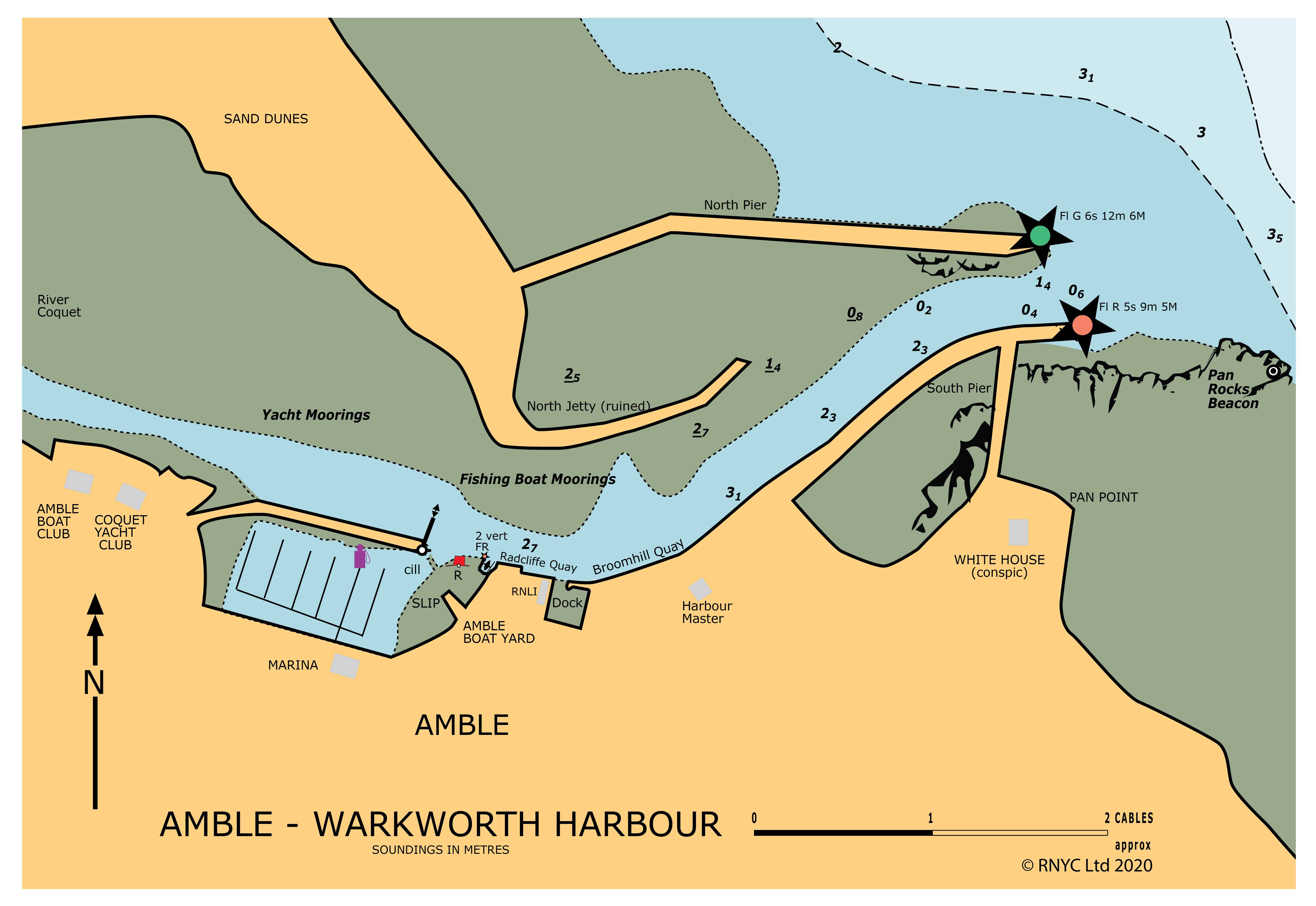
Click chart to zoom.
Passing between Coquet Island and the mainland, the major danger is the Podler Ware Spit with a least depth of 0.3 metres. If the tidal height is sufficient for clearance then the channel is over 2 cables wide.
From the south pass to seaward of Hauxley Head. This is on the junction of the red and white sectors of Coquet Light. A good line for Coquet Channel is the white house on Pan Point in line with the keep of Warkworth Castle, although the latter is not always easy to pick out. As the narrows are approached the best water lies a cable from this line towards the island, with Amble North Pier bearing 297º.
If making for Amble the sewer outfall buoy is a useful mark. If heading north then keep at least 2 cables inshore of the island. Once past the northern end of the island you should be in the white sector of Coquet Light to avoid the Pan Bush. The Pan Bush is a dangerous shoal (0.3 metres) when there is any swell, as is the shoal north of Coquet Island. Passage through the area should not be considered in strong onshore conditions associated with any seas.
From the north, Amble is best approached inshore of the Pan Bush, heading for the entrance.
Passage outside Coquet Island from either direction is quite straightforward. At night the red sectors of Coquet Island cover Boulmer Stile to the north and Hauxley Head to the south.
From the east or south the Pan Rocks must be avoided. From the north the approach is clear.
There are several good anchorages, useful if waiting for water into Amble; north of the Harbour, off Hauxley Links and to the north-west of Coquet Island.
Entrance
Large scale dredging (in 2000) has considerably improved depths with 2 metres over the bar at low water but this cannot be relied on and without local knowledge the entrance should be approached only after a significant rise of tide. The location of the best water over the bar varies according to recent weather conditions and dredging. Local boats may give an indication. Give a good berth to the knuckle of the south pier then the channel follows the south side of the river.
The harbour entrance breaks in onshore conditions. If there is any doubt it is best to wait for high water. A guide to conditions can be gained from the Pan Bush; if it is breaking then the bar will be dangerous; but take care, as it can still be dangerous without this indication.
Amble Marina (VHF Ch. 80) will report on the current depth on their cill which will indicate the depth on the bar.
Moorings
The Broomhill Quay is busy with fishing boats and any stay is liable to be disturbed. The Radcliffe Quay, beyond the fishdock, is much quieter.
The Marina has a cill approximately 0.8 m above Chart Datum.
There is a tide gauge at its entrance.
The Marina is entered between the old wooden jetty and a port hand buoy. Secure at the end of the second pontoon, beside the fuel pumps to receive berthing instructions. Out of hours, mooring instructions are left here in a box. Coquet Yacht Club has drying moorings up-river of the Marina which may be available.
Amble Marina
Please note, there is a cill at the entrance to Amble Marina which is 0.8m. Please contact Amble Marina for more information about access.
Coquet Yacht Club is grateful to RNYC for the reproduction here of this extract from RNYC Sailing Directions, Humber to Rattray Head ©RNYC. Copies may be obtained from chandlers and from RNYC for £25 + £5 p&p. Contact admin@rnyc.org.uk. If you are planning to cruise / visit the coast from the Humber to Rattray Head this guide provides an excellent source of information and guidance.
Chart image and text © RNYC. These directions are intended for aid and guidance only. These should not be used in isolation for navigation purposes. No responsibility is accepted by Coquet Yacht Club or Royal Northumberland Yacht Club for errors, omissions or inaccuracies in the above sailing directions. Please ensure you consult proper charts and or almanacs for the area and for your passage making.